
Billions of images captured by everyday people playing the mobile game Pokémon Go have been used to train an artificial intelligence model now being integrated into US military technology.
Niantic Spatial, a company that emerged from the original developer of the game, owns approximately 30 billion scans of streets, buildings, and parks submitted by players over the years, according to The Guardian on June 12.
We bring you stories from the ground. Your support keeps our team in the field.
DONATE NOW
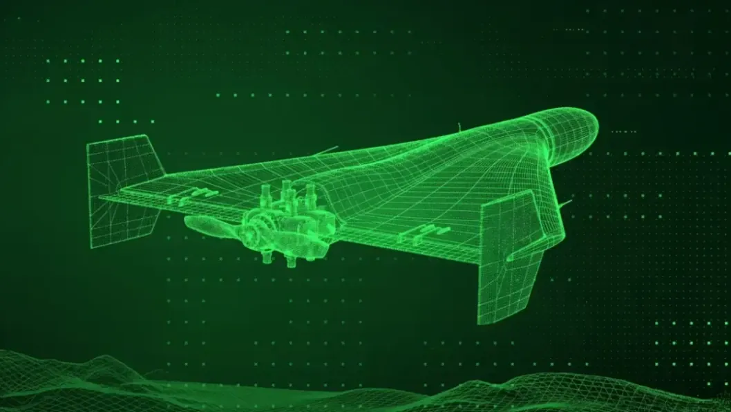
This vast dataset has been used to refine a navigation system that defense contractor Vantor is currently deploying in drones and other military robotics to enable navigation without relying on GPS.
The technology relies on a Visual Positioning System, or VPS. While traditional GPS systems can be vulnerable to signal jamming or spoofing—tactics frequently employed during Russia’s full-scale invasion of Ukraine—a VPS allows autonomous systems to determine their location by matching camera feeds against a pre-existing, highly detailed 3D map of the environment.
Because the system utilizes physical landmarks and terrain rather than satellite signals, it offers a more resilient alternative for operations in challenging or contested areas.
The transition from a gaming tool to a military asset began in 2021, when Pokémon Go introduced features encouraging players to scan real-world locations in exchange for in-game rewards. According to reports from the specialized industry portal DroneXL, these scans provided the raw material necessary to build the 3D models now used by Niantic Spatial.
Read more
- Category
- World
In December 2025, the company announced a partnership with Vantor, a defense firm formerly known as Maxar Intelligence, to integrate these capabilities into military hardware.
“On the modern battlefield, there are different systems, and they need to be upgraded quickly,” said Peter Wilczynski, Director of Products at Vantor. The companies state that the partnership is designed to “eliminate a critical vulnerability of modern operations” by ensuring precise navigation.
Representatives from both companies confirmed that Vantor does not have direct access to the raw photos captured by gamers; instead, it utilizes the AI model that was trained using that data.
A spokesperson for Niantic Spatial noted that the scans were “provided voluntarily by players who opted into the feature and were subject to the applicable terms of service and privacy policy at the time.”
Read more
- Category
- Defense Tech
However, experts in digital rights suggest that the average user was likely unaware of the long-term implications of their actions. “We know that most people do not read lengthy legal documents when they want to play a video game,” said Tom Sulston of the Digital Rights Watch think tank.
Ukraine turned its battlefield data into a strategic resource by sharing millions of drone videos and combat recordings with local firms and international allies to train military artificial intelligence models.
This extensive dataset, which included annotated frames from tens of thousands of combat drone flights, was managed through a secure platform created at Ukraine’s Ministry of Defense. Developers submitted their code to this platform to train AI models without gaining direct access to classified information, allowing the system to automatically spot enemy targets while keeping sensitive data protected.
Both defense officials and partners emphasized a “human in the loop” model, ensuring that while the AI identified and recommended targets, the final decision to engage always remained with a human operator.

Our reporters work on the frontlines to show what’s really happening in Ukraine. Your support helps them keep reporting.


